
The benefits of regular exercise for our physical and mental well-being are well known. This was especially true during the height of the pandemic, and many of us took the opportunity to get out and walk around our neighborhoods, Quarry Lake, Meadowbrook Park and other local nature areas. Baltimoreans are also blessed to have beautiful walking/hiking/biking trails along local abandoned railroad lines. In addition to the exercise, these make for a wonderful family outing on Chol Hamoed Sukkos or anytime. Described below are some of the most accessible and popular.
The Northern Central Railroad (NCR Trail), officially known
as the Torrey C. Brown Trail, runs for nearly 20 miles in Maryland, starting
from Ashland Road (just off Paper Mill) in Hunt Valley to the Mason-Dixon Line.
It then continues as the York County Heritage Trail into Pennsylvania, ending
in York. The trail is part of the East Coast Greenway, a 3000-mile trail that
connects 15 states and 450 cities and towns from Maine to Florida. For 134
years, from 1838 to 1972, the NCR carried passengers and freight between
Baltimore and York and led to the growth of small towns all along the route.
During the Civil War, Union troops were transported south on the railroad from
military training camps in the north. Abraham Lincoln traveled on the NCR on
the way to deliver his Gettysburg Address, and later, after his assassination,
his body would be transported to Harrisburg on the same line. Increasing truck
and automobile competition marked the decline of the railroad, and its death
knell was in 1972 when Hurricane Agnes washed out bridges and made the line
impassable. The Maryland Department of Natural Resources (DNR) converted the
abandoned rail bed into a multiuse trail in 1984.
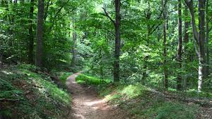
The well shaded,
wheelchair accessible NCR trail has a hard-packed limestone surface and is
10-feet wide. While mostly flat, there is a gradual elevation of 540 feet from
the south to north ends. Ideal for hiking, walking, running, and biking, the
trail can also be used for horseback riding. There is also access to the Big
Gunpowder River for trout fishing and tubing. Pets are welcome but must be kept
on a leash while on the trail. The heavily wooded and very scenic trail runs
along the Gunpowder River with nice waterfall viewing just north of Whitehall.
There is ample
parking on paved lots all along the trail in Ashland, Sparks, Phoenix, Monkton,
Whitehall, Parkton and Freeland. Access to parking in Ashland is off of York
Road, while access to other parking areas is off exits from I-83. In Sparks
there is a Nature Center, and in Monkton, a former railroad station has been
converted into a ranger station. Restroom facilities (often Spot-a-Pots) are
available near some of the parking areas. The NCR is very popular, especially
on holidays and Sundays, and parking areas often fill up early. However, the
trail is much less congested at the northern end above Monkton, especially on
weekdays.
Lake Roland Park, centered in the Jones Falls Valley,
provides over 500 acres of an exceptionally diverse ecosystem of wetlands,
meadows, hardwood forests, rare serpentine rock barrens, and many endangered
species of shrubs and trees. The first chromite mines in the U.S. were established
here in the early 1800s. The park is leased from Baltimore City but managed by
Baltimore County in partnership with the Lake Roland Nature Council.
Recreational and educational features include many shaded trails for walking,
running, hiking, and biking, a Nature Center staffed by park rangers, a dog
park, two picnic pavilions, a children’s nature play area, and an area to
launch kayaks and canoes. A paved parking area can be accessed off Falls Road
just north of Lake Avenue. There is also park access from the Falls Road MTA
station via a boardwalk located at the rear of the MTA parking lot. Although
technically illegal, some visitors use informal shoulder parking along Falls
Road just south of Old Court.
The area
encompassing Lake Roland was part of an 18th century land grant from
Lord Baltimore to several Maryland families. The centerpiece of the park is the
reservoir (man-made lake) that was formed in the 1850s as a water source for
the city of Baltimore. One remaining structure from those days is the beautifully
restored Greek Revival stone pump house that sits adjacent to the dam and
waterfall. The MTA light rail line runs along a former railroad embankment and
trestle over the lake and above the dam, cutting the park into a two-thirds
wooded northern section and a one-third southern portion around the dam, picnic
groves and pavilion. The right-of-way of the former Northern Central Railroad,
which ran from Baltimore to Harrisburg, PA, is near the southern end of the
lake. This part of the park also includes a portion of the former Greenspring
Valley Railroad right-of-way, along which trains ran from Lake Roland and
through the Greenspring Valley before meeting up with the Western Maryland
Railroad near Reisterstown Road.
Informative trail
maps are available at the Nature Center or on the park website. Most trails are
packed down dirt and may be muddy after rainstorms. The most popular two-mile
red trail the and 0.8- mile blue trail are level, but other trails (purple and
orange) leading to environmentally sensitive areas are moderately hilly and
rocky. Along the red trail there is interesting trail art, a mid-century modern
home inspired by Marcel Breuer, remnants of abandoned tracks and ties from the
Northern Central Railroad and, on warm sunny days, great turtle viewing at the
southeast end of the trail.
Dogs are welcome
on the trail but must be leashed at all time, even when wading in streams. Park
rangers are on the lookout to fine violators. Unfortunately, except for the
pavilion area, the park is not handicap accessible. The park is busiest on
Sundays and holidays, times when parking might be tight. At other times parking
is not a problem and the trails are not too crowded.
Stony Run Trail is a somewhat undiscovered urban
gem providing a great outdoor nature experience in the northern section of
Baltimore City. The walking/running/biking path runs for 2.8 miles following
Stony Run Creek parallel to Charles Street and Roland
Avenue through 15 Baltimore neighborhoods, including Roland Park, Guilford, Hampden,
Tuscany-Canterbury and Remington. Starting at the Gilman School athletic
fields, the trail passes Friends School, Loyola University, and the edge of the
Hopkins campus, ending at 33rd Street and Wyman Park Drive. One
could call it a very “educational walk.” At its midpoint, the trail passes
Linkwood and Oakdale Parks, and at the end of the trail, one can easily walk to
the Hopkins Homewood Campus and the Baltimore Museum of Art. Between Wyndhurst
and Coldspring Avenues, there are parallel paths on either side of the creek
which can be crossed at both ends. There is one short stretch after Linkwood
Park where one has to walk on a neighborhood sidewalk and across a short
pedestrian bridge which leads to Oakdale Park, a popular spot for unleashed dog
running. At its southern end, the trail narrows and is at a higher elevation
than the creek providing lovely views of wetlands and a forested, gorge-like
setting, making one forget that he/she is in the middle of Baltimore City. The
trail is mostly level over packed-down dirt with some roots and loose gravel.
Well maintained by the City and Friends of Stony Run, the trail is well shaded
and even after wet weather, is rarely muddy. A detailed description of the
trail can be found at Baltimorecityparks.com.
Stony Run sits on
the former rail bed of the Maryland and Pennsylvania (Ma & Pa) railroad,
which was established in 1901 to carry passengers and freight from Baltimore to
York, PA, via Towson and Bel Air along a meandering and very scenic 70-mile
journey. Loss of a U.S. mail contract and competition from cars and trucks led
to the discontinuation of passenger service in 1954 and a complete shutdown of
the line in 1984. When walking the trail, one can still see remnants of soot
from the coal-fired steam engines on the underside of bridges spanning the
former rail line.
When Gilman School
is not in session, its parking area off Northern Parkway provides direct access
to the north end of the trail. Other access points with street parking are
available at Wyman Park Drive and Sisson Street, University Parkway at
Linkwood, Stony Run Park at West Coldspring Lane, and Wyndhurst Avenue and
Wilmslow Road. The trail is not handicap friendly, and there are no restrooms
available. Dogs are welcome but must be leashed, except in Oakdale Park. Except
on Sundays and holidays, Stony Run is not very crowded.
The next time that someone tells you to “take a
hike,” thank them for their advice, grab your